AMS 105- American West: Images and Identities
|
AMS 105- American West: Images and Identities |
|
|
IV. Emerging Regional Identities |
Regionalism: Division of a country or area into smaller units based on geographical and/or cultural differences.
| A. Rocky Mountains |
The Rocky Mountain region basically follows the continental divide in the US and extends into Canada. It includes parts of Utah, Colorado, Wyoming, Montana, and Idaho. This region tends be one of the popular images generated by artists and would be only second to the Southwest. Films in the 1960s and 1970s began using the Rockies as a backdrop. A number of our National Parks are included in this area.
| National Park | Features | Date Established |
| Rocky Mountain NP, Colorado | Longs Peak 14,259 feet | 1915 |
| Mesa Verde NP, Colorado | Prehistoric ruins of ancient Pueblo people | 1906 |
| Black Canyon of the Gunnison NP, Colorado | Gunnison River is a tributary of Colorado River | 1999 |
| Zion NP, Utah | Oldest of Utah's NP and most dramatic canyons | 1919 |
| Bryce Canyon NP, Utah | Unique geologic formations from erosion | 1928 |
| Canyonlands NP, Utah | Colorado River and Green River expansive canyons | 1964 |
| Arches NP, Utah and Capital Reef NP, Utah | near Moab with fantastic rock art | 1971 |
| Grand Teton NP, Wyoming/Montana | Most dramatic mountain backdrops; especially Jenny Lake | 1929 |
| Yellowstone NP, Wyoming/Montana/Idaho | Huge caldera with hot springs and great wildlife | 1872 Oldest National Park |
| Glacier NP, Montana | Great mountain highway through the main pass | 1910 |
The Rocky Mountains are a young mountain range and present a dramatic feature
to this region mixed with plains, desert and mountain meadows. The ruggedness
inhibited dense settlement but stimulated intrusion in the form of mining and
forestry, which is referred to as extraction industry. Many people exploited the
resources and simply left after leaving their refuse. Thus you still have
numerous ghost towns and areas abandoned.
 One
could argue that the expansive West still seems to attract people that dump
their trash more than in the East Coast areas, simply because it appears wide
open.
One
could argue that the expansive West still seems to attract people that dump
their trash more than in the East Coast areas, simply because it appears wide
open.
On the other side of the coin the Rocky Mountains, private and public
attracts tourists. Some of this is associated with recreational winter sports,
where old mining areas became ski resorts for the rich and famous.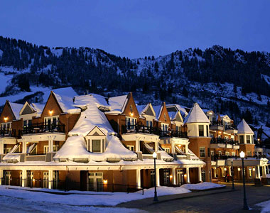 Aspen, CO
B. Pacific Northwest
The Pacific Northwest includes Oregon, Washington and Idaho and tends to emphasize the presence of salmon. However, salmon run in California, British Columbia, Canada and Alaska. Yet, the emphasis of salmon still does dominate the image of the Pacific Northwest. The salmon basically start in the cold mountain streams and migrate to the ocean for 7-10 years and return up river through the Cascade Mountains into the west side of the Rocky Mountains to spawn and die.
Salmon (Oncorhynchus sp.)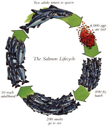
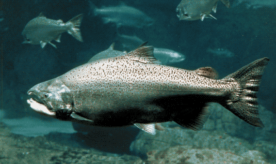
| Names | Habits |
| Chinook (King) | largest of the salmon, up to 122 lbs; 5-7 yrs.; Spring and Fall runs |
| Chum (Dog) | up to 10 lbs; 3-5 yrs. |
| Coho (Silver) | up to 15 lbs.; 3 yrs. |
| Pink (Humpback) | up to 5 lbs.; only 2 yrs. most plentiful |
| Sockeye (Red) | up to 7 lbs.; richest flavor/deep red flesh |
| Steelhead | up to 40 lbs.; like a rainbow trout but with runs twice a year |
The Pacific Northwest has some fertile farmland and semi arid regions, but the western slope of the Cascades is virtually a temperate rainforest with rainfall over 150-200" / year. Therefore, besides fishing there was mining, hydroelectric, farming/orchards and Pacific Rim shipping. Recently a thriving wine industry has emerged. Tourism is also important and includes National Parks.
| National Park | Features | Date Established |
| Crater Lake NP, Oregon | 1902 | |
| Mt. Rainer, NP, Washington | 1899 | |
| Olympic NP, Washington | 1938 | |
| North Cascades NP, Washington | 1968 |
The striking physical view of the Cascade Mt. volcanoes makes this area unique. The Pacific Northwest has prided itself as having an environmental track record that was progressive, but recent trends show that nuclear waste and degradation of the salmon population indicate more problems than expected.
C. Montana
Montana as part of the Northern Plains and Rocky Mountains was a 'late bloomer' for pioneers and has never supported large populations. Like its state nickname, 'Big Sky Country' it is an expansive landscape that really extends into Canada. Native Americans acquired horses and shifted to a dramatic pastoral culture that depended on the American Bison. The Blackfeet developed horse culture to suit the landscape and even after the Bison were gone became great bronco riders. European Americans brought in cattle but because of harsh winters had to mix Scottish cattle like the Angus. Nevertheless, conditions were harsh in those Northern Plains and in the Great Blizzard of 1886-1887 thousands of cattle died. Montana remained somewhat underdeveloped and populated even into the 1990s. As an advertising gimmick the phrase "the Last Best Place" began to catch on and draw in the rich and famous to get away from congestion. People could afford to travel back and forth but wanted the open range look with 'Big Sky', wildlife, cowboys and Indians. This identity continues today but it is becoming more crowded and conflicts between animal species, like grizzly bears, old timer ranchers and city slickers have emerged.
| National Park | Features | Dated Established |
| Glacier NP, Montana | Really part of Jasper up in Canada | 1910 |
| Yellowstone NP, Montana | North Gate in Montana | 1872 |
D. Southern California
Southern California is a diverse landscape with even more diversity of people. The environment originally came with sagebrush and chaparral from the Pacific Ocean through inland valleys and deserts and in the surrounding Peninsular Range. Some riparian oak environments that once dominated the valleys exist only in isolated park settings as well as some mountain trees above 3,500 ' in a few parks. The original California Indian people are poorly understood or ignored until the emergence of gaming (1989). As writer/historian, Carey McWilliams describes, the "Spanish Fantasy Past" provides an idealized base for the later Anglo American. This continues with suburban sprawl naming streets with Spanish names like Vista de Caballo Way. As development chewed up the natural environment the Missions were tourist attractions with fiestas trying to bring back those 'rancho' days. On the downside were the non distinct Indian peons in pure white cotton outfits.
Initially the railroads and Pacific Rim trade for lumber, sugar and other products brought in a small elite that built mansions, usually in a Mission Revival style. Unfortunately, the mild climate stimulated these people into converting the coast desert to a tropical 'paradise'...anything grows in Southern California. This continues to tax the water supply and only recently has xerotropic landscaping become the vogue. More Anglo Americans came as the film, TV and music industries moved from the East Coast to the West Coast in consecutive waves from the 1920s-1990s. Service and labor work brought in many groups from the East, Pacific Rim and Latin America (mostly Mexico). During the depression foreign immigrants and Dust Bowl refuges poured in, but WWII caused a need for labor from outside with African Americans coming for defense work and Mexicans invited in the Bracero Program to provide farm labor. With the various exclusion acts against Asian immigrants and the Relocation Act of Japanese citizens the need for outside labor increased. The war also brought in a greater military presence in Southern California and resulted in even greater diversity. Subsequent wars brought in many additional groups (Korean, Vietnamese, Iranian and beyond).
As heavy industry and agriculture diminished in California, tourism, fashion, and high tech became more prevalent. Los Angeles has become the most ethnically diverse city in the United States. Unfortunately, water has become like gold and drought trends make it worse in combination with an increase of aridity and fires.
|
National Park |
Features |
Date Established |
| Channel Islands NP | Difficult to visit | 1980 |
| Joshua Tree NP | Mojave Desert System | 1994 |
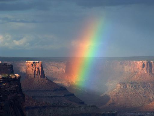
E. Southwest
The Southwest has a very colorful and dramatic landscape that eventually was
used (John Ford) extensively in films and in the tourism industry with publications like Arizona Highways. This
landscape is a variant desert driven mostly by geological forces and altitude.
The high desert 3-5,000 feet is recognizable with juniper scrub and conifers;
while the low desert is creosote scrub with saguaro cactus.
and in the tourism industry with publications like Arizona Highways. This
landscape is a variant desert driven mostly by geological forces and altitude.
The high desert 3-5,000 feet is recognizable with juniper scrub and conifers;
while the low desert is creosote scrub with saguaro cactus.
 Grand
Canyon, AZ Grand
Canyon, AZ |
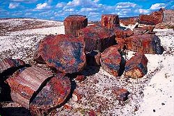 Petrified
Forest, AZ Petrified
Forest, AZ |
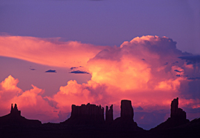 Monument
Valley, AZ Monument
Valley, AZ |
The Native American culture was in place and its ruins and arts were
exploited for tourism. The most visited prehistoric ruin in the US is Mesa Verde
NP and smaller ruins at Grand Canyon NP. There is a very prevalent Spanish
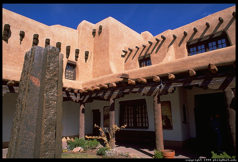
colonial and Mexican base, but it is oriented to old towns like Santa Fe that
was established in 1598. The older Spanish architecture is very common in the
Southwest including public buildings, old and new.
 Some
Anglo-Americans came to ranch and settle, but often blended in a less
superficial way than California. Later, the Southwest became a mecca for East
Coast and Midwest Americans looking for the health benefits of the desert.
Unfortunately they too brought plants not suited to a desert climate.
Some
Anglo-Americans came to ranch and settle, but often blended in a less
superficial way than California. Later, the Southwest became a mecca for East
Coast and Midwest Americans looking for the health benefits of the desert.
Unfortunately they too brought plants not suited to a desert climate.
Since American Indians were not totally removed they are far more visible and a great part of the tourism. When railroads came entrepreneurs like Fred Harvey used trains as a direct pipeline for American Indian arts like pottery, weaving and jewelry. The repercussions for this were mixed with culture change driven by market tastes of non Indian collectors, but with economic benefits that often were a life saver to the community.
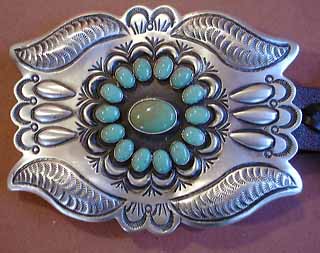 Navajo
belt buckle Navajo
belt buckle |
 San
Ildefonso Pueblo, Maria Martinez San
Ildefonso Pueblo, Maria Martinez |
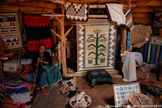 Navajo
loom and rugs Navajo
loom and rugs |
In spite of these changes, the Southwest and its people have retained a good deal of traditional traits. Mining and urban sprawl have done the most damage. A water shortage is a problem for all of the West especially for the urban areas like Phoenix, Las Vegas and Los Angeles compeating for the same water. Borderland problems include labor needs, drugs and illegal weapons are also part of the Southwest.
| National Park | Features | Date Established |
| Mesa Verde NP, CO | Ancient Pueblo Ruins (40 sites); Cliff Palace | 1906 |
| Arches NP, UT | visit Moab and surrounding rock art | 1971 |
| Petrified Forest NP, AZ | prehistoric petrified wood | 1962 |
| Grand Canyon NP, AZ | the deepest canyon that still presents and awesome view | 1919 |
| Saguaro NP, AZ | saguaro cactus preservation | 1994 |
| Carlsbad Caverns NP, NM | deep limestone cavern | 1923 |
| Big Bend NP, TX | Chihuahuan Desert and Rio Grande River canyons | 1944 |
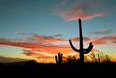
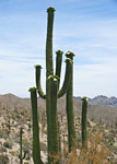 Flowering
Saguaro cactus
Flowering
Saguaro cactus
Next: V. Current Images and Identities
Back To Main Page
Copyright © by S. J. Crouthamel 2013