|
PREHISTORIC CULTURES OF NORTH AMERICA |
| S. Crouthamel, American Indian Studies/Anthropology |
VI. Far West Traditions
The Far West includes the Pacific Coast of North America with the Northwest
Coast and California; and the Intermountain Region (between Sierra/Cascades and
Rocky Mountains) that includes the Plateau and Basin. Some consider the American
Southwest as part of what is called the West, but we will consider it separate
in these notes and the course outline. The four areas of the Far West have their
own particular differences that American Indians adapted to,
which resulted in many different cultures. The common aspect is that
these people were almost exclusively hunting and gathering (H&G). Also, the general environmental
pattern is that the Northern areas are forested and in some cases are temperate
rain forests with precipitation levels reaching 200+" rainfall per annum. As you
travel into the Southern areas and east the environment becomes arid and
semi-arid with precipitation dwindling down to < 15" rainfall per annum. Coastal
environs, rivers, lakes, altitude, soil and relative orientation to the sun
(North facing slopes vs. South facing slopes) further account for differences in
weather and biological variations/diversity. The archaeological record and data
tell a story of increasingly complex Archaic H&G adaptations by the people, in
conjunction with climatic fluxuations referred to as:
| Anathermal |
decreased mean temperatures |
<8,500 BC (<10,500 BP) |
| Medithermal |
mean temperatures |
> 4,500 BC (>6,500 BP) |
| Altithermal |
increased mean temperatures |
8,500-4,500 BC (10,500-6,500 BP) |
In actually there various small anathermals and altithermals, even as
late as the 1940's and even today (with the resultant controversy of causes). So
as people in the Far West improved their Archaic adaptations they were sometimes
met with climatic changes with resultant socio-political crises, including the
migration of new peoples.
We have simplified these changes into three basic phases Early (9,000-4500
BC) (11,000-6,500 BP), Middle (4,500-1,000 BC) (6,500-3,000BP) and Late (1000 BC - AD 1500)
(3,000-500 BP). Such
simplification has its drawbacks and distortions, but is useful in the
beginning.
| Far West |
Early Tradition |
Middle Tradition |
Late Tradition |
| Northwest Coast |
Cordilleran
|
Riverine-Interior
|
Maritime Coastal
|
| California (S. California) |
San Dieguito
|
La Jolla/ Pauma
|
San Luis Rey/Cuyamaca
|
| Plateau |
Cordilleran
|
Riverine
|
Riverine/B-H Complex
|
| Basin |
E. Desert Archaic
|
M. Desert Archaic
| 2000BC-AD 500 |
Lovelock Cave |
|
L. Desert Archaic/Fremont
|
A. The Northwest Coast was inhabited by Paleo-Indian
people and later groups from the Arctic, Subarctic, and Plateau. Recent genetic
evidence indicates the people of the Northwest today have a much greater
diversity than was ever imagined for such a narrow geographic region. The
Cascades and the Rockies come together in British Columbia that forms a weather
barrier very close to the Pacific Ocean. The mountains eventually run into the ocean at
Glacier Bay, Alaska. The warm Japanese Current sweeps down
the Northwest Coast and provides a virtual temperate rain forest, that rich in
sea and land resources. The Pacific Ocean was rich in fish and sea mammals. The
most important were the seven species of salmon (Oncorhynchus sp.). The salmon are anadromous.
They are born in fresh water streams in the Rocky Mountains and then migrate
into the Pacific Ocean only to return upon maturity to their freshwater origins
to spawn and die. On the land, in the rich rain forest, were many plants and
game, but the cedars were the most useful for houses, utensils, canoes and totem
poles.
The archaeological record and artifacts in early sites indicate that people
initially exploited the forest and riverine environment and later moved closer
to the mouths of the rivers and the ocean. Artifacts indicate lithics for H&G of game animals,
barred fish spearheads, and net/fish basket trap weights. Around 1000 BC (3,000
BP)
people had moved to the coast at the mouths of rivers and began to develop maritime
lifestyles including whaling. Recently, a whaling village, Ozette, along the
Olympic Peninsula, Washington was excavated. The site is unique in that a
mudslide partially buried houses and preserved entire house artifacts including
cordage, textile, baskets and wood.
SITES: Site #2:Ozette, WA; Hoko River, WA;
Friendly Cove, Vancouver Is., Canada
B. Plateau people were located in an interesting intermountain region
of Oregon, Washington, Idaho and British Columbia between the High Cascades and
Rocky Mountains. This environment was considerably drier than the coast, but it
had two great river systems, the Frazer River running from the Canadians Rockies,
through the Cascades and into the Pacific Ocean at Vancouver, B.C. and the
Columbia River system running from the Canadian Rockies and U.S. Rockies, through
the Cascades between the states of Washington and Oregon. Many
species of salmon migrated up these rivers through the Cascades into the Rockies
to spawn. Such a resource provided a great deal of added food to the land base
resources. On land deer, sheep and elk were abundant as well as many lake and
river plants. In the mountain meadows the camas bulb ( blue camas/Camassia
quamash) was an important staple. People were hunting and gathering in this environment
as early as 10,600 BC (12,600 BP). Initially they live in in rock shelters and later in semi-subterranean pit houses.
Fish were part of the diet early on (7,000 BC +/-) but as the area became more
arid so too fishing became more important; with summer and fall runs for
different species of salmon. Many fishing techniques were used, including nets and traps with
weirs and platforms along narrow rapids to get access to the running of the fish. One of the most important places
for this was on the Columbia River at Celilo Falls and Five Mile Rapids near the Dalles, OR.
This was one of the great rendezvous points on the continent and up to 10,000
Indians came to trade at this point in the Fall, since the abundant salmon could
support so many. The Dalles dam has since flooded the area and destroyed the
falls. The Plateau riverine culture was most developed beginning about 2,500 BC
(4,500 BP). After, AD 1750
some of the Plateau people, like the Yakima and Nez Perce acquired horses
and added summer buffalo hunts into the Plains to their seasonal patterns.
However, they never left the river salmon runs like some of the other cultures that migrated
to the Plains. The people wanted to return for the Fall salmon runs and spend
winters on the rivers.
C. California is an area that begins in the north with the cedar and redwood forests,
and ends in the south with increasingly arid areas of sagebrush scrub. In fact California is one
of the most diverse areas of the Far West. The boundaries of the culture area of
California does not perfectly match the current state as most scholars extend the culture
area into Baja (Lower) California to Ensenada. Some areas east of the Sierra
Nevada Mountains are often put into the Basin. Our U.S. state of California was designated
Alta (Upper) California by the Spanish. For the original American Indian
cultures California, west of the Sierra Nevada, was a relatively
rich environment with temperate rainforests in the north and coastal lagoons in
the south. Throughout most of these valleys and foothills weres Riparian Oak
forest/scrub. The many oak species provided a staple food of acorns, that, once
leeched, were a very nutritious food resource. The evidence of the extensive
processing of acorns is throughout the state in the form of bedrock mortars and
other milling features. As the text author notes, California was not a 'Garden of Eden', but it was rich in wildlife
both on land and sea, and had the mildest
in climate on the continent. Yet, California
was not an untouched wilderness, but a managed park-like environment modified by burning
and careful H&G management strategies. At times climatic changes in the form
of altithermals or earthquakes caused difficult times. However, the attraction to the relatively
mild climate was for American Indians as it is today....everyone wants to come to
California and worse they stay. Alfred Kroeber likened this prehistoric and
historic phenomena to a
fish-trap...it draws you in but you can not go back. The result is that all the
major language groups, except
Eskimo-Aleut found their way to California in the last 10,000 years. The Hokan
language is the original language with the others coming in from the north and
the east 7,000-1,000 years ago.
The Early Tradition sites indicated general hunting and
gathering strategies with a preponderance of lithics; including cores, core
tools, bifacial blades, domed scrapers, and side scrappers. During the Middle
Tradition specializations adapted to coastal, riverine, lake, valley and foothill
environments. Prevalent artifacts included fishing implements and pecked grinding tools,
especially mano/metate. The grinding tools are free standing in some cases or
bedrock if available. The Late Tradition reveals increased exploitation
of acorns matched by the increase of portable and bedrock pestle/mortars. California has more species of oak (perennial and deciduous) than anywhere else
in the world. Many species had large acorns (nuts) that were protein and fat
rich. These nuts had to be leeched of tannin or tannic acid (like cassava,
cashews, olives). It is likely that the intensification of acorn use was in part
due to increasing aridity and new people coming into the area from even harsher
areas like the Great Basin. The Late Tradition began in California about 2000
-3,000 years ago (different from text) and includied a much greater focus on
seeds, nuts and less game in the valleys, as well as increased coastal use
of shellfish, fish, sea mammals and birds along the coast. The Southern
California Channel Islands represented maritime adaptations, including the use
of a
unique planked canoe (tomol in Chumash) that allowed for to travel from the mainland
and the islands.
California has more species of oak (perennial and deciduous) than anywhere else
in the world. Many species had large acorns (nuts) that were protein and fat
rich. These nuts had to be leeched of tannin or tannic acid (like cassava,
cashews, olives). It is likely that the intensification of acorn use was in part
due to increasing aridity and new people coming into the area from even harsher
areas like the Great Basin. The Late Tradition began in California about 2000
-3,000 years ago (different from text) and includied a much greater focus on
seeds, nuts and less game in the valleys, as well as increased coastal use
of shellfish, fish, sea mammals and birds along the coast. The Southern
California Channel Islands represented maritime adaptations, including the use
of a
unique planked canoe (tomol in Chumash) that allowed for to travel from the mainland
and the islands. Such rich resources in the ocean, trade networks and acorns produced dense
populations and increased social hierarchies that
were represented in the archaeological record by special art objects, money shells
(dentalium, clam and olivella) and greater trade networks. Thus the Northwest
Coast and California developed relatively dense H&G populations, that mirrored
agricultural social hierarchies.
Such rich resources in the ocean, trade networks and acorns produced dense
populations and increased social hierarchies that
were represented in the archaeological record by special art objects, money shells
(dentalium, clam and olivella) and greater trade networks. Thus the Northwest
Coast and California developed relatively dense H&G populations, that mirrored
agricultural social hierarchies.
SITES: Gunther Is., Humboldt Bay; Molpa, Tomkav; Site #3-PC-3
D. The Great Basin is, as it's name implies, a high altitude
desert basin. The Great Basin is the northern part of the Western Deserts
extending into the Southwest, California and Northern Mexico, but it is an
intermountain region (Sierra Mts. and Rocky Mts.) which has alkaline soil and
drainage only into alkaline sinks like the Great Salt Lake and Mono Lake. These
conditions rendered the Great Basin as a harsh and inhospitable environment that became
increasingly arid into the present.
|
Great Basin Climatic Fluctuation |
Time Periods |
| Anathermal (cool/moist) |
11,000-7,000 BP (9,000-5,000 BC) |
| Altithermal (hot/dry) (+ 20˚
F.mean) |
7,000-4,500 BP (5,000-2,500 BC) |
| Anathermal (~today's mean temp. ) |
4,500 B P- 0 BP (2,500 BC-present) |
The American Indians were sparsely populated and all derived from the Aztec-Tanoan
language. During the summer, in some areas of the Great Basin 15 sq. miles of
land was
required to support one human being. Some people left and went to California,
others experimented with CBS agriculture (Fremont Tradition), but those that
persisted fine tuned their ability to hunt and gather in seasonally exploited econiches in this high desert environment. By the Late Tradition the people
would seasonally move from lower elevations, 2500' above sea level, in the spring
to higher elevations, 9,000 ' above sea level, in the fall.
|
Great Basin Econiches |
Altitude
(feet above sea level) |
Plant Community |
% use |
|
Lower Sonoran |
0-2,500 |
Creosote-Saltbush |
1% |
| Upper Sonoran |
2,500-5,000 |
Saltbush-Grass |
10% |
| Transitional |
5,000-7,000 |
Juniper-Pinyon |
82% |
| Canadian-Hudsonian |
7,000-9,000 |
Oak/Aspen-Pine/Fir |
5% |
| Boreal |
9,000 + |
Mt. Meadow-Heath |
2% |
The hunting and gathering during the late tradition focused on Pinyon Pine
nuts ,
seeds, incects,
jackrabbit, antelope, and bighorn sheep. Rock shelter sites like Lovelock Cave,
Danger Cave, and Hogup Cave provided dry environments that preserved the
perishable artifacts like cordage and baskets that add to the lithic inventories
during the Early through the Late Traditions of the Great Basin. Furthermore,
plant remains preserved in these caves gives an even greater window into the
kind and quantity of food used by these people.In the southern regions of the
Great Basin in Utah and Nevada maize (CBS) and pottery are added to the H&G
inventory. This may represent a Southwest expansion of people and or ideas into
the Great Basin and is referred to as the Fremont Tradition. However, around
AD 1300, the Fremont experiment was abandoned and considered part of a Southwest
Tradition expansion.
,
seeds, incects,
jackrabbit, antelope, and bighorn sheep. Rock shelter sites like Lovelock Cave,
Danger Cave, and Hogup Cave provided dry environments that preserved the
perishable artifacts like cordage and baskets that add to the lithic inventories
during the Early through the Late Traditions of the Great Basin. Furthermore,
plant remains preserved in these caves gives an even greater window into the
kind and quantity of food used by these people.In the southern regions of the
Great Basin in Utah and Nevada maize (CBS) and pottery are added to the H&G
inventory. This may represent a Southwest expansion of people and or ideas into
the Great Basin and is referred to as the Fremont Tradition. However, around
AD 1300, the Fremont experiment was abandoned and considered part of a Southwest
Tradition expansion.
SITES: Lovelock Cave & Hidden Cave, NV; Danger Cave & Hogup Cave, UT
These patterns and changes were similar throughout the Far West
and show that these Archaic cultures had to fine tune their adaptive strategies
to survive and in some cases thrive. Certain
environments, such as lakes, allowed for very special adaptations. Also, arid
environments mentioned gave archaeologists out of the ordinary preservation
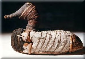
conditions for 'soft' artifacts. One example of these artifacts were the duck decoys found in the cave sites of the
Great Basin. They were made of tule reeds to float but were covered with a duck's skin
to make them even more realistic and attractive to the quarry..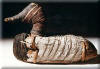 These
were discovered in 1924 and are estimated to be at least 2,000 years old.
These
were discovered in 1924 and are estimated to be at least 2,000 years old.
Copyright © by S. J. Crouthamel
2013
 California has more species of oak (perennial and deciduous) than anywhere else
in the world. Many species had large acorns (nuts) that were protein and fat
rich. These nuts had to be leeched of tannin or tannic acid (like cassava,
cashews, olives). It is likely that the intensification of acorn use was in part
due to increasing aridity and new people coming into the area from even harsher
areas like the Great Basin. The Late Tradition began in California about 2000
-3,000 years ago (different from text) and includied a much greater focus on
seeds, nuts and less game in the valleys, as well as increased coastal use
of shellfish, fish, sea mammals and birds along the coast. The Southern
California Channel Islands represented maritime adaptations, including the use
of a
unique planked canoe (tomol in Chumash) that allowed for to travel from the mainland
and the islands.
California has more species of oak (perennial and deciduous) than anywhere else
in the world. Many species had large acorns (nuts) that were protein and fat
rich. These nuts had to be leeched of tannin or tannic acid (like cassava,
cashews, olives). It is likely that the intensification of acorn use was in part
due to increasing aridity and new people coming into the area from even harsher
areas like the Great Basin. The Late Tradition began in California about 2000
-3,000 years ago (different from text) and includied a much greater focus on
seeds, nuts and less game in the valleys, as well as increased coastal use
of shellfish, fish, sea mammals and birds along the coast. The Southern
California Channel Islands represented maritime adaptations, including the use
of a
unique planked canoe (tomol in Chumash) that allowed for to travel from the mainland
and the islands. Such rich resources in the ocean, trade networks and acorns produced dense
populations and increased social hierarchies that
were represented in the archaeological record by special art objects, money shells
(dentalium, clam and olivella) and greater trade networks. Thus the Northwest
Coast and California developed relatively dense H&G populations, that mirrored
agricultural social hierarchies.
Such rich resources in the ocean, trade networks and acorns produced dense
populations and increased social hierarchies that
were represented in the archaeological record by special art objects, money shells
(dentalium, clam and olivella) and greater trade networks. Thus the Northwest
Coast and California developed relatively dense H&G populations, that mirrored
agricultural social hierarchies.